Travelling to Iceland is a journey to some of the wildest, most breathtaking scenery in the world.It’s an arctic circle island where glaciers meet volcanoes, creating otherworldly landscapes. Geysers blast boiling water out of portals in the earth, glacier ice washes up on ink-black beaches, and rushing waterfalls fall off geometric columns of basalt.
This is also the ancestral home of the Vikings, with historic grass-roofed longhouses to visit. There is incredible food, from locally fished langoustines to hot dogs that US presidents have tried. Arctic wildlife is there to spot, from whales to puffins, even the Icelandic pony! And to top it off, Reykjavik is a cool, colourful, artistic capital that charms anyone who visits. But, planning a trip to Iceland can be daunting, because of the sheer number of sights, remote locations, and difficulty pronouncing names.
So, where to begin your planning?
Iceland in 2 Weeks
2 weeks is perfect for a road trip around Iceland. It allows enough time to explore the entire country via its wonderful ring road, Route 1, and still gives enough time to sit back and relax few a few days in Reykjavik.
Just Follow Route 1 all The Way
Route 1 traces a rough circle shape around the entirety of Iceland, leaving mountainous regions in the centre. Along the way, sights are impossible to miss. Tourist attractions are marked with an apple looped square symbol (⌘) on a sign, whilst the biggest draws, like glaciers, take up the whole horizon as you approach! The biggest question you need to ask yourself is whether to drive clockwise or anticlockwise. This itinerary keeps the momentum of a road trip going by spending one night in each stop; more nights can easily be added and taken from the Reykjavik nights.
- Day 1-3: Reykjavik
- Day 4: drive from Reykjavik to see the Golden Circle, and onwards to Vik.
- Day 5: Explore Vik and surrounding sights. Drive onwards to Skaftafell Nature Reserve.
- Day 6: A day of hiking in Skaftafell nature reserve. Drive to Hofn, stopping to see the glacier lakes of Vatnajokull along the way.
- Day 7: Drive from Hofn to the puffin colonies.
- Day 8: Drive to Myvatn geothermal area to see Hverir and bathe in the blue pool.
- Day 9: overnight in Akureyri.
- Day 10: Akureyri to Reykjavik.
- Day 11-14: Sightseeing in Reykjavik.
Hiring a Car
Let’s keep it simple – yes, you absolutely need to hire a car for a road trip around Iceland. And no, it doesn’t need to be a 4×4. There are lots of hire car options available at Keflavik airport, which can be booked in advance (they’ll even meet you at the arrivals terminal to take you to their office). The choice ranges from big, tough 4x4s, to beat-up, second hand hatchbacks (SadCars, which I used for this trip).
Sticking to Route 1, you won’t need to go offroad.
Let’s begin!
***
Reykjavik
Reykjavik is Iceland’s colourful, cool capital city. Even though it’s only got a population of 120,000, Reykjavik is the the biggest city of Iceland.

If you want to simplify it, it’s a small, cold, remote port city – but don’t let that honest description put you off. Reykjavik is actually an exciting hub of art, design, great food and coffee, with friendly people, awesome hot dogs and a fascinating Viking history.
Reykjavik is also the starting point for most people’s adventures onwards into the country, and many people hire cars here, and stock up on supplies for the road.
So while you’re staying in Reykjavik, what is there to see and do?
Laugavegur Street
To orient yourself, start at Laugavegur Street, the main commercial street and tourist hub. Packed with restaurants, painted murels and flowers, this pedestrian-only street is one of Reykjavik’s highlights.
If you’re not shopping for souvenirs or taking pictures of the public artwork, check out the Chuck Norris Grill, or sit down with a coffee and listen to headphones in one of the great music stores.
Hallgrimskirkja Church
The Hallgrímskirkja church, at the top of the city, is the tallest and most conspicuous building in Reykjavik. With a flared rocket shape, and wings of concrete, the church is inspired by volcanic basalt columns.
Inside, check out the 15-metre tall pipe organ, designed and built by Johannes Klais from Bonn. The colossal instrument weighs 25 tons, and comprises 5275 pipes!
Leif Erikson Statue
Just outside the church is a statue of Leif Erikson (970-1020), an Icelandic explorer who was the first European to land on North American soil. He landed at L’Anse aux Meadows in Canada, predating Christopher Columbus by 500 years.
The Sun Voyager Sculpture

The Sólfar sculpture at the waterfront looks reminiscent of a skeletal Viking longboat; in fact, sculptor Jon Gunnar Arnason intended this striking piece to be a ‘dream boat’, a symbol of light and hope.
Overlooking the waterfront, and with Mount Esja in the distance, the Sólfar is one of the best photography spots in the city.
Reykjavik’s Famous Hot Dogs – Baejarins Beztu Pylsur
Reykjavik’s best hot dogs are on the waterfront, on Tryggvagata, near the Reykjavik Art museum. Baejarins Beztu Pylsur has been iconic since 1937, and has even served Anthony Bourdain and Bill Clinton!
Expect a hot dog in a bun with raw onions, crispy fried onions, rémoularde, and their secret mustard-ish sauce.
The Settlement Exhibition
A small, but interesting historical museum, the settlement exhibition is built on the remains of an old Viking longhouse. It is also called Reykjavik 871±2, named for the year of the ruins.
***
The Golden Circle
There is a trio of spectacular sights just outside of Reykjavik – Gullfoss waterfall, Geysir geothermal area, and Thingvellir. Together, they make up the best day trip in the country, the Golden Circle.
While seeing these sights make for a great round trip, they are also a perfect starting point for travellers extending their trip onwards to the rest of Iceland.
So, what are these places?
Gullfoss Waterfall
Gullfoss is also known as the ‘Golden Falls’, and is a spectacular sight. From afar, you can’t see the waterfall, only a huge plume of white spray jetting into the sky. Thats because Gullfoss drops down into a fissure, so viewers can watch the falls from above.

The river Hvitá drops water 32 metres in a two-tiered drop, which also bends at a 90 degree L shape. Like a corner staircase, it drops diagonally in one direction, then in the opposite diagonal, disappearing into a crevice.
It’s a furious and dramatic sight, watching the water churned so violently into such a small space. In fact, Gullfoss is the largest volume waterfall in Europe, owing to the high rainfall and glacial runoff.
Geysir Geothermal Area
The next stop on the Golden Circle is Geysir geothermal area. Named after Geysir, the geyser that gave all others their name, it is translated from the old Icelandic word geysa, ‘to gush’.
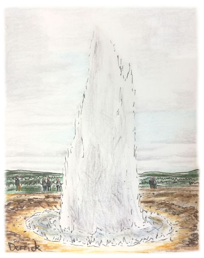
The Great Geysir itself is actually in a dormant phase, and hasn’t erupted in years. But when it did, it could project boiling water from a hole in the earth as high as 70 metres into the air.
But don’t be disappointed that it’s not active any more – many smaller geysers are still active, such as Strokkur geyser, which blasts water 30 metres high every 5 or 6 minutes.
The geothermal temperatures have turned the land into a strange landscape of trickling blood-orange streams, stinking yellow sulfur stains, slick green algae, and black volcanic mud. They are chemical deposits from the earth, and add to the otherworldliness of the area.
Þingvellir
The typical first stop on the Golden Circle is the Þingvellir National Park. The Icelandic symbol Þ is pronounced like ‘th’, so this is pronounced Thingvellir.
This UNESCO site is significant for two reasons. Firstly, it lies right on the tectonic fault line between the North American and European plates. Iceland is sliced in two by this mid-Atlantic ridge, with the Eurasian Plate to the east, and the North American Plate to the west. The fissures in the earth formed here produce gaping bottomless pits and cheer cliff faces.
It doesn’t look like you expect, perhaps a chaos of volcanoes and chasms; in fact, the whole area is blanketed in soft, fluffy moss and calm, clear springs from the fertile soil. The underwater caves here are also suitable for diving and snorkelling, with crystal clear waters that filter through the rock.
The area also has a cultural significance; early Icelandic parliaments met at this location in the 10th century to discuss the governing of the country. Once the tents and structures were up, these national assemblies (called AlÞingi) began. Public speaking took place at the Lögberg, or Law Rock, where the country’s ‘law speaker’ discussed items, and invited any other members of the public to share their opinions and concerns.
***
Vik
Moving south from the Golden Circle, the next notable stop along Route 1 is Vík í Mýrdal. Simplified to Vik, this small, pretty village at the very south of Iceland looks like a postcard.

This small settlement of about 300 people is in a stunning location, built not far from the sea in a valley cradled by cliffs.
Indeed, it is these surrounding rock formations and landscapes that are the main attraction here. There are mighty sea rocks, poking out of the water like Poseidon’s trident. There are clusters of basalt columns, forged together into amazing bundles of hexagonal rock. There are rock archways, distant glaciers, and even a green valley that looks like it’s from another planet.
What to do in the Village of Vik
- Reyniskirkja Church – Vik’s only landmark building is a white, wooden, minimalist building with a tall, red-roofed spire. It’s very pretty, and looks great in photographs from any angle. It’s even available to host weddings!
- Reynisfjara black sand beach – along the shoreline of Vik is this unusual, but stunning beach. Black sand and stones make it less than ideal for sunbaking, but it’s worth checking out for the sweeping cliff faces on the right, and the sea stacks just off shore.
- Reynisdrangar sea stacks – those sea stacks are basalt rock spikes that conjure up images of a sea monster’s teeth. Legend has it that these basalt rock spikes were created when two trolls attempted to drag a three-masted ship to land, and when the sun rose, they turned to stone.
- Voyages Friendship statue – a tall, square column with a leaning silver figure pointed towards the sea. It was inspired by the families who feared for the lives of their loved ones who worked out at sea.
Camping in Vik
Vik has an active camping scene (and limited hotels, if any), and is the best way to experience this amazing little village. Plots of grass are plentiful, but remember to dress warmly, even in the middle of summer.
A common building has toilets and showers, as well as a lively dining room with basic kitchen facilities and a great view of the sea.
What to see around Vik
To truly enjoy Vik, you’ll need to hop in the car for some quick 5-10 minute drives to nearby sights.
Dyrhólaey Rock Formations
The beach at Vik is nice for photos, but the nearby Dyrhólaey peninsula is in a different class. The word translates to ‘door hill island’, named so because this volcanic outcrop used to be a separate island, but has now joined up with the mainland.
Dyrhólaey Rock Arch
The most instantly recognisable feature if the Dyrhólaey rock arch, a basalt outcrop which has a tunnel eroded through its base. Climbing on top gives great views all the way down to Vik, with the sea stacks of Reynisdrangar clearly visible. Boats can pass underneath, and in 1993 one brave pilot even flew a plane through it!
Hexagonal Basalt Columns
Walking down to the beach level at Dyrhólaey, and across the pebbles, there are fascinating clusters of basalt rock formations. They form when lava flows from an eruption, and then the basalt volcanic rock dries quickly (a matter of weeks). Because of the rapid drying, the basalt splits in very particular shapes, giving the hexagonal columns we see.

Fjaðrárgljúfur Gorge
Leaving Vik, the Fjaðrárgljúfur gorge is further down the highway. It is a squiggly-shaped gorge that is difficult to describe.

This gash in the earth begins at a high plateau, and works it’s way downwards to sea level. Along the cliffs on either side, the rocks have eroded into rounded precipices, standalone columns, and grass-covered outcrops.
If you’ve ever studied high school biology, the shape is something like an endoplasmic reticulum.
The grassy hills that lead up to around Fjaðrárgljúfur are easy enough to climb, but rise sharply, offering a hundred terrifying viewpoints. The palagonite walls of the canyon are not straight; they are smoothed off and eroded down, warped and precarious, like a mouth full of crooked teeth, shaping themselves into the tiniest (most vertigo-inducing) viewpoints.
The site is very unknown, and visitors are rare. Tour buses can’t do the offroad drive, and the sign for the turnoff is blink-and-you’ll-miss-it.
***
Skaftafell Nature Reserve
From Vik, the next major stop is the mighty Vatnajökull National Park. A subsection which is known for outdoor activities is Skaftafell Nature Reserve, a wild area that is on the edge of Europe’s largest glacier.
Skaftafell is surrounded by glacier tongues and glacier lakes, volcanoes, and some truly magnificent waterfalls.
Hiking Trails in Skaftafell
There is a visitor’s centre that offers information and maps, because Skaftafell is all about trekking – easy, hour-long walks, or epic full-day adventures that require crampons for glacier hiking. There are also several campsites available nearby.
Here are the easiest (and shorted) walking trails in Skaftafell Nature Reserve.
Easy Walking Trails
I’m going to focus on two of the easiest trails for people of average fitness, who are staying for just one day, and which also offer some of the most iconic views of the Skaftafell area.
- Skaftafellsjökull (3.7km round trip, 1-1.5 hours), a flat trail that leads to a glacier lake, and a close up view of the glacier.
- Svartifoss/Sjónarsker/Sel (5.5km round trip, 2 hours), an uphill hike to one of Iceland’s most incredible waterfalls.
These two treks are easily done back-to-back.
Skaftafellsjökull Glacier Lake Trail
The walk from the visitor’s centre to the glacier outlet at Skaftafellsjökull is the easiest hike to do. It’s a flat march through low, hardy bushes and flowering mountain plants, and takes around half an hour to reach the glacier lake.
The best part about this walk is watching the immense scale of the glacier become more and more pronounced as your approach. What starts off as a distant white glimmer soon becomes a colossal ice river, and it fans out into a plain of black sand.
At the shores of the glacier pool, the glacier suddenly seems twenty metres high and hundreds of metres across! The muddy lake, where blocks of ice calve off into the murky water, is spectacularly cold to touch. A few icebergs drifted and melted slowly in the lake, and creates a very serene scene.
Svartifoss Waterfall
The Svartifoss waterfall walk is a 1.5km trail, which takes about an hour in each direction, mostly uphill through low greenery.

Svartifoss waterfall is very elegant. The 20-metre drop runs down into a rocky enclave. Framing the waterfall are hundreds of vertical basalt columns that gives Svartifoss a very organised, geometric look. The hexagonal columns actually serve as inspiration for Reykjavik’s iconic church.
***
Vatnajökull Glacier Lakes – Fjallsárlón and Jökulsárlón
From Svartifoss, Route 1 continues to circle the southern section of Vatnajökull National Park. Along the way, there are several outstanding glacier lakes to visit.
Vatnajökull National Park
In 2008, Vatnajökull was designated a national park, incorporating the existing national parks of Skaftafell and Jökulsárgljúfur. Now, it’s Europe’s largest national park, occupying 13% of Iceland’s total area.

The size of the glacier is astounding – 8300 square kilometers. That’s bigger than the island of Crete, and nearly as big as Hawaii’s Big Island! The national park has seven volcanoes beneath the surface of the ice, and all of them are active, with the most recent eruption in 2011.
Fjallsárlón Glacier Lake
The viewpoint of Vatnajökull glacier is stunning from the Fjallsárlón glacier lake. From afar, it looks like a furious avalanche roaring down the mountain, frozen in place. The glacier lake itself is quiet, still, and reflective, with huge ice blocks floating in the waters.

Jökulsárlón Glacier Lake
The neighbouring Jökulsárlón glacier lake is just down the next road. It is also formed by Vatnajökull’s ice. Jökulsárlón is much larger, more dramatic, and is filled with thousands of ice blocks that twinkle like shattered blue glass.
There’s a lovely ambience, watching the tail end of a glacier. There was no noise but the wind, and the drip drip of melting ice. Occasionally an iceberg would creak under stress, or a small chunk would fall into the water with a soft plop.
Jökulsárlón Black Sand Beach
Just down the road, the runoff from the glacier flows out to see via a narrow channel. The result? Icebergs make their way out to the ocean, and then wash up again on the black sand beach.
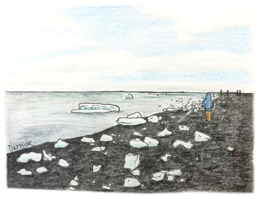
The beach, black as night with volcanic sand, is covered in lumps of ice, collecting on the sand or drifting back and forth in the dark water. They are polished smooth and crystal clear from their wash in the sea, contrasting profoundly with the black sand. It is a truly jaw-dropping sight!
Höfn
After a day exploring the glaciers and the glacier lakes, the best place to stop for the night is Höfn, a small fishing town on the east coast (the town name literally means ‘port’).

The town was tiny and quiet, and beautiful in the sunset. Down by the waterfront, the mirror-flat harbour projected perfect copies of the fishing boats at anchor.
Langoustine
Höfn has a local reputation for serving fine seafood, in particular the speciality of the region – langoustine, a mini lobster from the Atlantic.
There were several great choices of seafood restaurant around, and they all appeared to be converted warehouses at the harbour. I chose to eat at Pakhús, ordering the langoustine (of course). The langoustines are served a dozen or so at a time, served in melted butter and herbs. Delicious!
***
Spotting Puffins at Borgarfjörður Eystri Fjord
The road to see the puffin colonies on the east coast of Iceland is a winding mountain drive.
Seyðisfjörður, on the far east coast of Iceland, was featured in the movie Walter Mitty, and is a very charming, picturesque little town.
On a clear day, you can see tall, snowy mountains, a still blue fjord, and a community of coloured wooden houses planted alongside a wooden church. It’s a good place for a rest, or to sit down in one of their cute cafe’s for a coffee and a hot bowl of soup.
Bakkagerði, the Puffin Colony
However, to find the puffin colony, you’ll need to drive to nearby Bakkagerði. It is by the sea, on the other side of a mountain range, and it’s necessary to deviate from Route 1 to access.
The road from to Bakkagerði is route 94, a long, gravelly, spine-shaking off road highway, leading on to winding mountain roads.
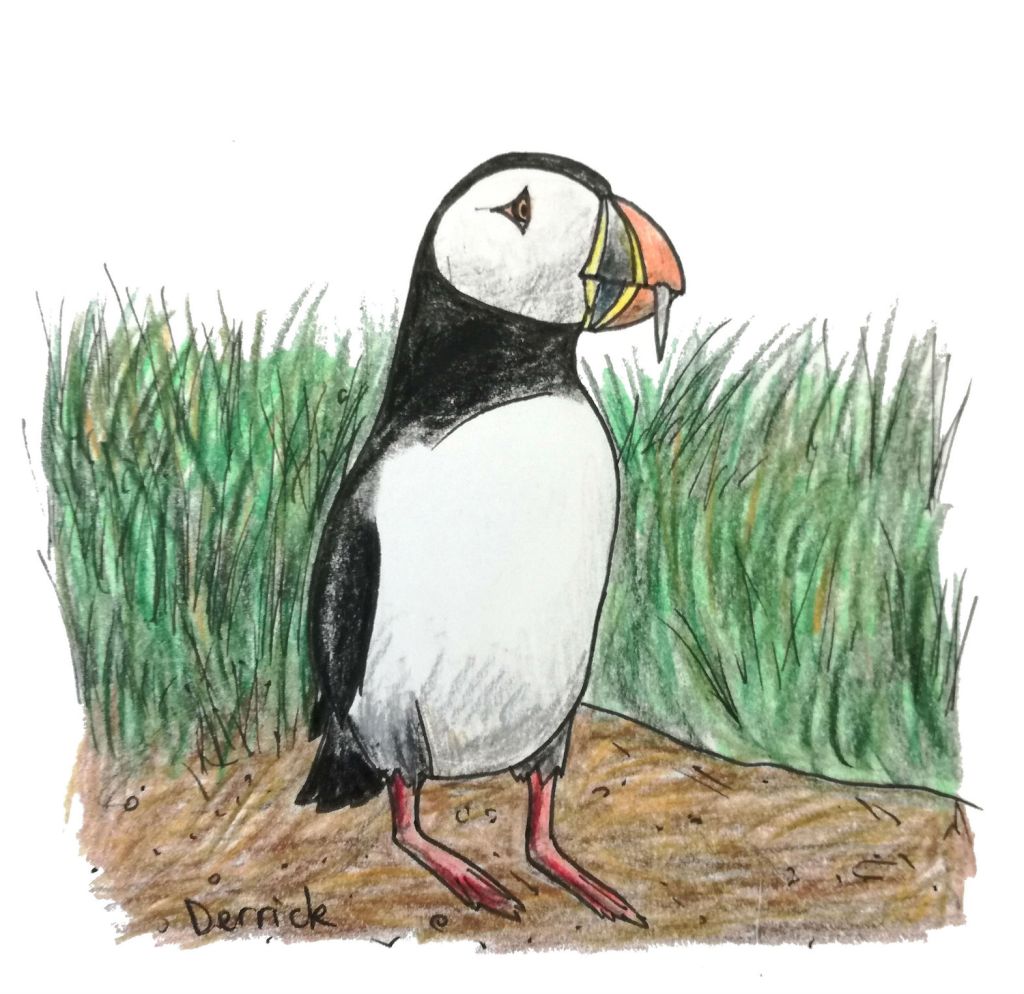
The puffins nest and fish at the end of a small peninsula, just past the town, high atop an outcrop of sea rocks.
The puffins look slightly comical in real life, with big heads, sad eyes, and oversized beaks stuffed with fish. Others flapped past in short bursts of flight, their short wings beating furiously as they circled their nests. Meanwhile, fisherman puffins dive-bomb the sea for food.
They share their home with noisy seagulls, screeching and complaining noisily in their cliffside nests.
Mývatn and Hverir Geothermal Area
Leaving the east coast the next day, the aim is to reach Lake Mývatn, a fascinating region of waterfalls, volcanoes and geothermal activity.
Hverir
Hverir is one of the features surrounding Lake Mývatn, an interesting geothermal site that feels like a chemistry set bubbling under your feet.
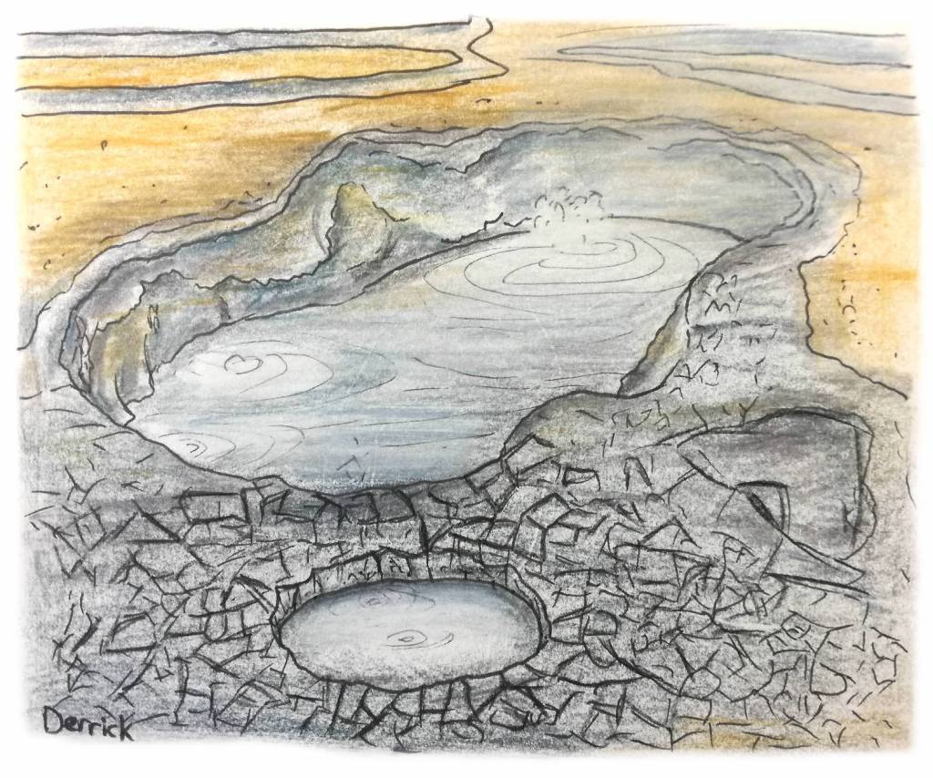
The area smells strongly of sulfur, a thick and choking stench of rotten eggs. It fumes out of the earth in billowing clouds through vents in the ground, past stacked stone piles encrusted with yellow sulfurous deposits.
Clouds of the steam rushed up all around the site in white plumes. The earth is orange here, stained grey and white in wide swathes where the earth’s minerals had boiled up to the surface and crystallised.
Bubbling pits of sloppy dark grey mud were burping and popping in boiling pools. It’s a funny experience to look inside one of these craters, and be met with a bursting bubble (with a comical gloooop).
The site is generally quiet, and if you go firt thing in the morning, there shouldn’t be too many tourists.
Dettifoss waterfall
A short drive away is Dettifoss, which features in the intro to the movie Prometheus. This was actually the largest waterfall in Iceland, and is a spectacular, raging torrent to witness.
The falls are a short drive from Mývatn, down a lonely highway and well signposted, swallowed by kilometers of fields of sharp grey rocks. But as you approach on foot, it announces itself with a distant roar. Then up close, Dettifoss has a loud, strong voice to match its physical power.
From edge to edge, Dettifoss was rushing water at it’s most turbulent, a moving wall of grey and white, never-ending. Certain outcrops of rock allow you to stand right on the edge of the action, bathed in the spray.
Krafla volcano
It wouldn’t be Iceland unless there was a volcano close by, and in Mývatn the closest is the site at Krafla. Near Krafla, a geothermal power plant straddles the road, plugged into the earth via a network of Super Mario pipes, space station domes, and steam vents.
Hot springs
To complete your day at Mývatn, there is the Nature Baths, a natural spring heated from underground, designed for swimming.
Entry to the pool is through the shower rooms (only after a nude pre-shower), which is compulsory for all visitors. The air outside is freezing cold, but thankfully, the springs were perfectly warm.
The pool is a fluro azure blue, with steam lifting from its surface. Hovering somewhere around 40 degrees, the water smells faintly of sulfur, and feels slippery on the skin.
***
Akureyri
Iceland’s fourth largest municipality is Akureyri, with a population of about 20,000. It is often referred to as the capital of the north.
Being such a small place, Akureyri doesn’t require much time to explore, but it’s a great base to stop on your road trip. While you rest and recharge in Akureyri, there are some cool things to see.
- Laufás turf houses – a row of historical homes, built of stone and with grass roofs.
- Whale watching – Akureyri offers some great whale watching tours, as well as porpoises and dolphins.
- Visit the arctic botanical gardens.
- See the northern lights (in winter).
Driving from Akureyri to Reykjavik
Driving from Akureyri to Reykjavik takes about 5 hours, and can fairly easily be done in one go.
Along the way, there’s some incredible landscapes and rest stops to keep an eye open for.
- Eiriksstadir – the Laufás home where Leif Erikson was born.
- Hraunfossar and Barnafoss waterfalls.
***
Tips for travelling in Iceland
Fuel stops in Iceland
Along route 1, fuel stops can be far between, so it’s good practice to always fill up if you’re at half a tank or less.
Outside of major urban areas, petrol stations are often unattended, and you’ll need a card with a PIN number to use the self-service pumps.
Iceland’s midnight sun
If you’re travelling in summer, then you’ll quickly learn that the country never gets dark. Around midnight, the sun dips close to the equator, and the sky turns a kind of deep blue…and then it makes its ascent again.
While this is a strange thing to see, it is also the perfect time to enjoy some midnight sightseeing (without crowds), and enjoy a still, calm, quiet experience in enchanting light.
Camping in Iceland
There is no better way to save money in an expensive country such as Iceland as camping. While avoiding hotel costs is obviously a great plus, the best thing about camping is the feeling of being in touch with nature. Nothing at all is better than laying in your sleeping bag, listening to the sounds of the waves, the wind, local sheep, and sea birds. After all, that’s why you came to Iceland!
Camping grounds are even available in Reykjavik!
***
Iceland is the perfect adventure destination for the intrepid; for those who are willing to brave the wind and the cold, and put in plenty of hours driving.
Because its so, so, completely worth it. Nowhere else is as wild, beautiful, stark and jaw-dropping as this land of volcanoes and glaciers.

Such a beautiful set of drawings loved every single one of them – you are so talented 🙂
Thank you, I’m glad you like them!! 😃
Loved this post! I love that it’s so detailed and informative and the illustrations are as usual, absolutely fantastic! Can’t wait to visit Iceland one day – you can be sure that I’ll be referencing this post to plan out the trip 🙂
Thanks very much! It was fun to go back through my Iceland trip and recreate all the things I saw with pencils.
I hope you’ll plan a trip to Iceland soon, it’s absolutely beautiful, and easier to travel through than it seems!
Iceland is a beautiful country. Thank you for a most complete tour of cities and the land with your added incredible drawings.
It’s a gorgeous place, and relatively easy to explore! Although at the end of the day, my drawings don’t do the scenery justice, and so many of Iceland’s sights have to be seen to be believed 🙂
Your drawings bring out the beauty of Iceland. Anybody can take a photo! 😊🥳
Oh, my , gorgeous drawings in this post..Iceland …yea, I still dream about this trip but fear the high cost unless one can find someone to share with …you do not talk about hotels along the route, not about cost…
Hi Paula, I’m glad you like my drawings! This is not so much a comprehensive guide with prices and recommendations, but rather an outline of what amazing sights you can see and do along the way. Iceland can be expensive as a solo traveller, but with some travel companions and using campsites, you can make it much more affordable.