Vík í Mýrdal, in the south of Iceland, is a small, pretty village that belongs in a picture frame on a fireplace. But looking beyond the spired church and small houses, nature is on display in all its elemental, brutal, striking glory.
Cliffs eroded by the ocean form natural arches, basalt column formations cluster and make geometric shapes, and jagged sea stacks rise from the waves, making the village look like a refuge in a land made by giants.
I awoke in a tent that was glowing green. My mind was frazzled, my body aching and stiff. Our night camping in Iceland had not been a comfortable one.
The night was only about four hours long, and the sun had barely dipped below the horizon before resuming its ascent.
Vík í Mýrdal, a village between the sea and the glacier
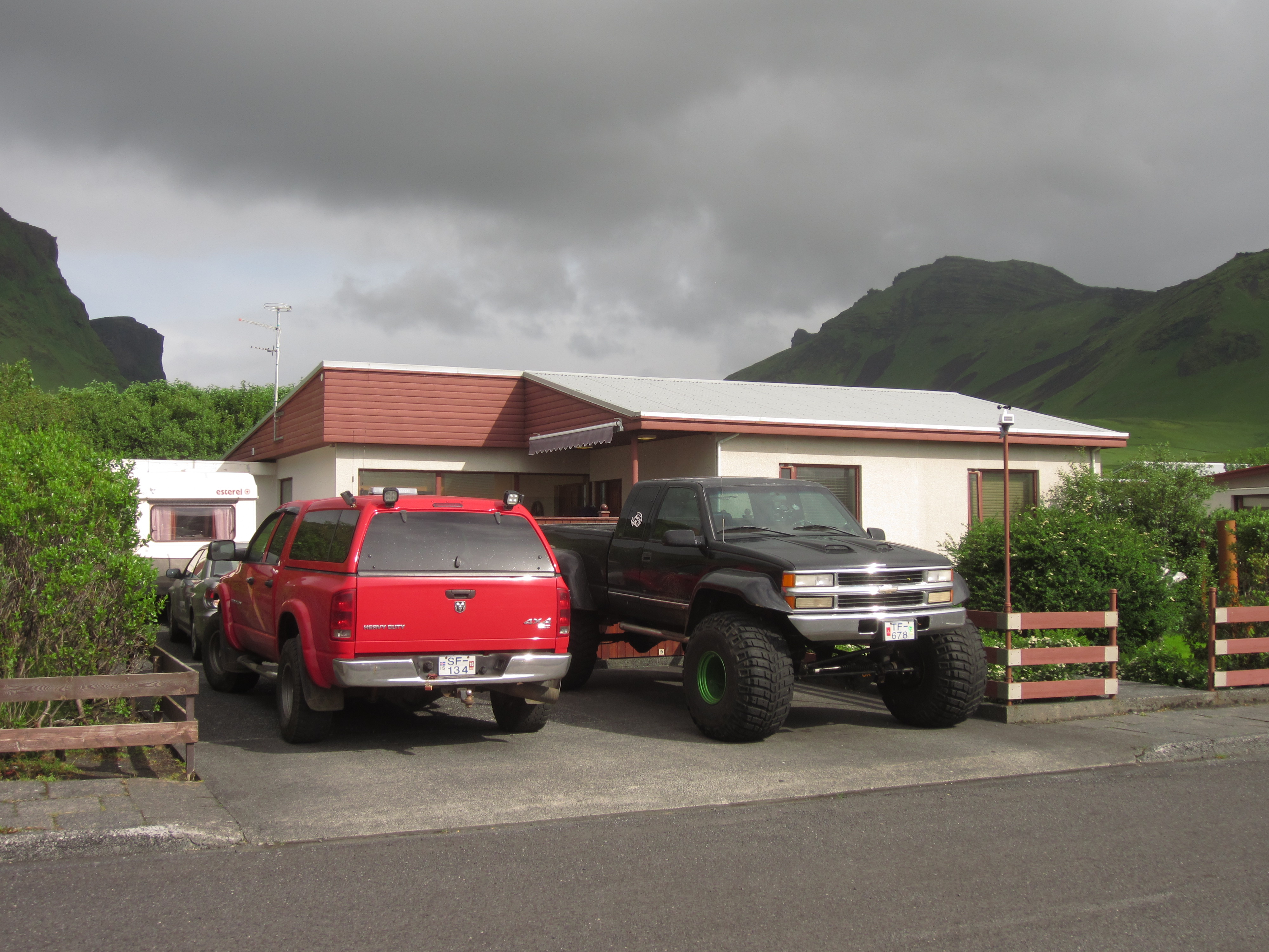
This small settlement of about 300 people is in a stunning location, built not far from the sea in a valley cradled by cliffs. Highway 1 runs through here, the major arterial ring road that passes around the country, making Vik an attractive rest stop for self-drivers.
The town was one of the few in Iceland with an easily rememberable and pronounceable name. Vík í Mýrdal is often shortened to Vik, meaning ‘port’, at the southern tip of Iceland. To the north, Vik is boxed in by the Mýrdalsjökull glacier, and the mountain passes draped over and around the Katla volcano.
There are some hotels around the Vik area, but camping is very popular as well.
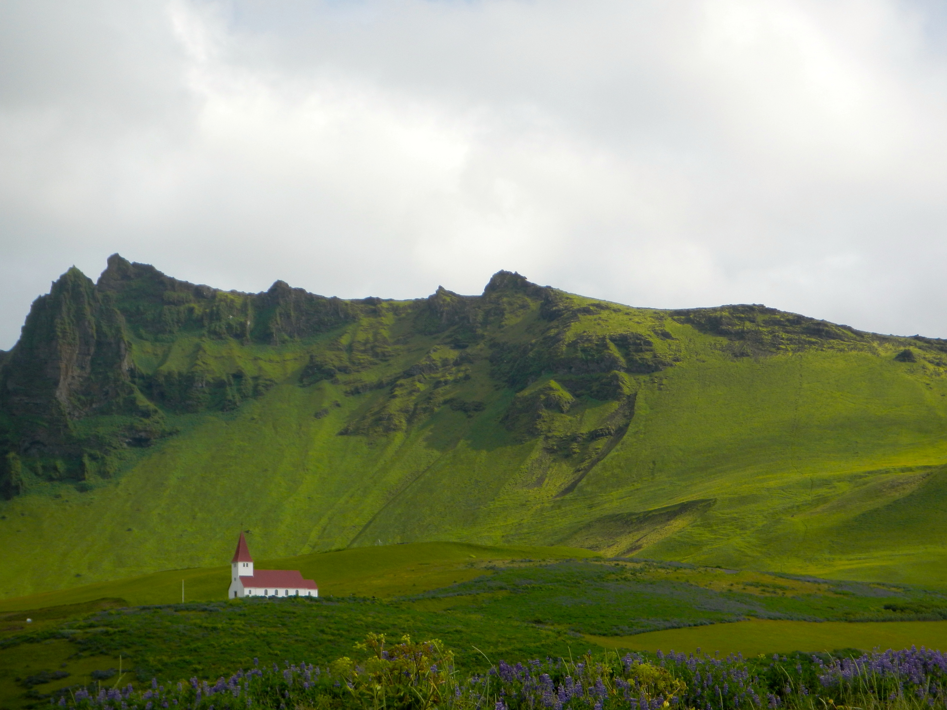
Vík í Mýrdal Church
Vik’s only landmark building is the Reyniskirkja white church, a minimalist building with a tall spire that comes up to a red-roofed point. It’s very photogenic, and great backgrounds are guaranteed no matter what angle you photograph it from! The church holds weddings, if you’re looking for a unique wedding ceremony in Iceland.
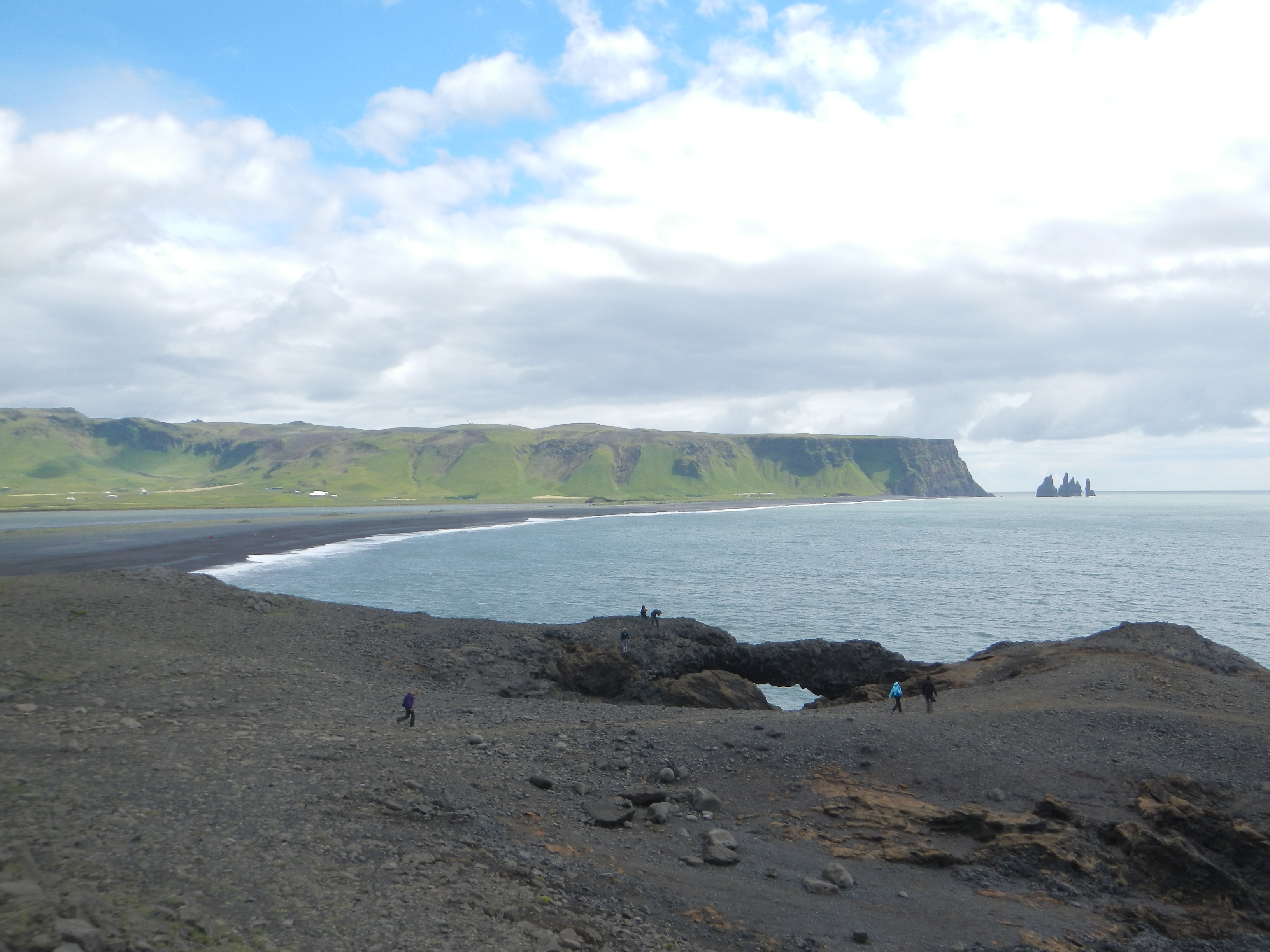
Reynisfjara Black Sand Beach
The beach at Vik is Reynisfjara beach, a black, stony beach that leads to a calm sea of blue-grey waves. The Atlantic seethed with dive-bombing fish raids by masterful sea birds. It’s certainly not ideal for swimming, but it might be one of the most beautiful beaches on earth.
On the right, a sweeping cliff face sweeps up to a flat plateau. And most notably, dead ahead are the staggering basalt sea stacks of Reynisdrangar.
Reynisdrangar Sea Stacks
The sea stacks off the coast from Vik beach are called Reynisdrangar, and they evoke the trident of Poseidon, or the teeth of some ancient legendary creature.
In fact, Icelandic legend has it that these basalt rock spikes were created when two trolls attempted to drag a three-masted ship to land, and when the sun rose, they turned to stone.

Voyages Friendship statue
At the top of a tall square column, Steinunn Thorarinsdottir’s aluminium statue of a figure leans towards the sea. This minimalist sculpture was was inspired by local families who feared for the lives of family members who worked out at sea.
Camping in Vik
The starless night sky, a rich blue, shone through the tent, producing a bright green glow. This was summer, and the sun never truly set this far north. It simply dulled the sky for a few hours, beforr rising into the sky again.
This was also supposed to be the warmest place in Iceland. Despite the season, I had underestimated the cold, and shivered through the night. The next morning wearing I emerged from the tent, pale and bleary-eyed, wearing every article of clothing I had packed.

Despite the rough first camp, it was absolutely worth it to marvel at where we were. Our tents were dwarfed by a sheer cliff, a colossal boulder serving as a wind block. Families of gulls squawked and complained noisily high above on the rocks.
The campsite had an adjacent building that had toilets and showers, as well as a common room with basic kitchen facilities and a large (warm!) dining room that looked out over the sea front.
Over breakfast, we planned our trips to nearby sights.
What to see around Vik
Vik is small. Very small. Walking to the beach and taking pictures is one of the things you have to do in Vik, but there isn’t much else do in the village itself. However, the true gems of the area are some of the surrounding geological marvels, and some short, 5-minute drives can take you to some outstanding spots.
Dyrhólaey rock formations
The beach at Vik is nice for photos, but the nearby Dyrhólaey peninsula is in a different class. The word translates to ‘door hill island’, named so because this volcanic outcrop used to be a separate island, but has now joined up with the mainland.

Dyrhólaey rock arch
The most instantly recognisable feature if the Dyrhólaey rock arch, a basalt outcrop which has a tunnel eroded through its base. Climbing on top gives great views all the way down to Vik, with the sea stacks of Reynisdrangar clearly visible. Boats can pass underneath, and in 1993 one brave pilot even flew a plane through it!
Hexagonal basalt columns

Walking down to the beach level at Dyrhólaey, and across the pebbles, there are fascinating clusters of basalt rock formations. They form when lava flows from an eruption, and then the basalt volcanic rock dries quickly (a matter of weeks). Because of the rapid drying, the basalt splits in very particular shapes, giving the hexagonal columns we see.

Mýrdalsjökull Glacier
Just beyond the view of Vik, a gigantic glacier was coming down the mountain. We could see them, and I was excited as hell. But before I talk about the soon-to-be-visited world of ice and glaciers, there was one more treat waiting for us.
Fjaðrárgljúfur gorge (try pronouncing that one!)
The canyon named Fjaðrárgljúfur was not easy to find.
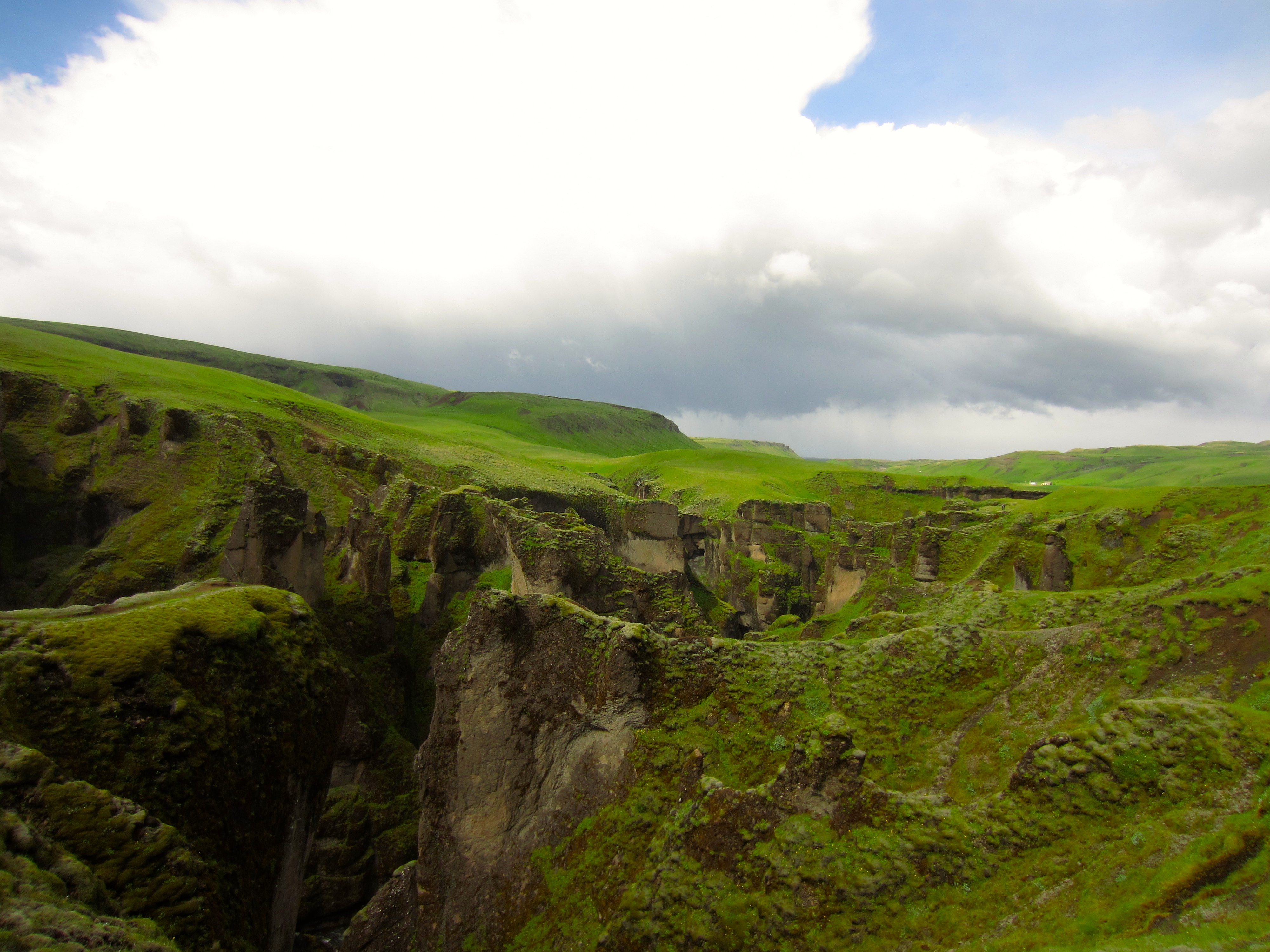
The road sign appeared suddenly. We crunched down a long gravel road in-between the mossy boulder fields and meadows, driving down inclines that I was positive our sad little rental car couldn’t re-climb (it did). At road’s end was a small carpark at the mouth of the canyon.
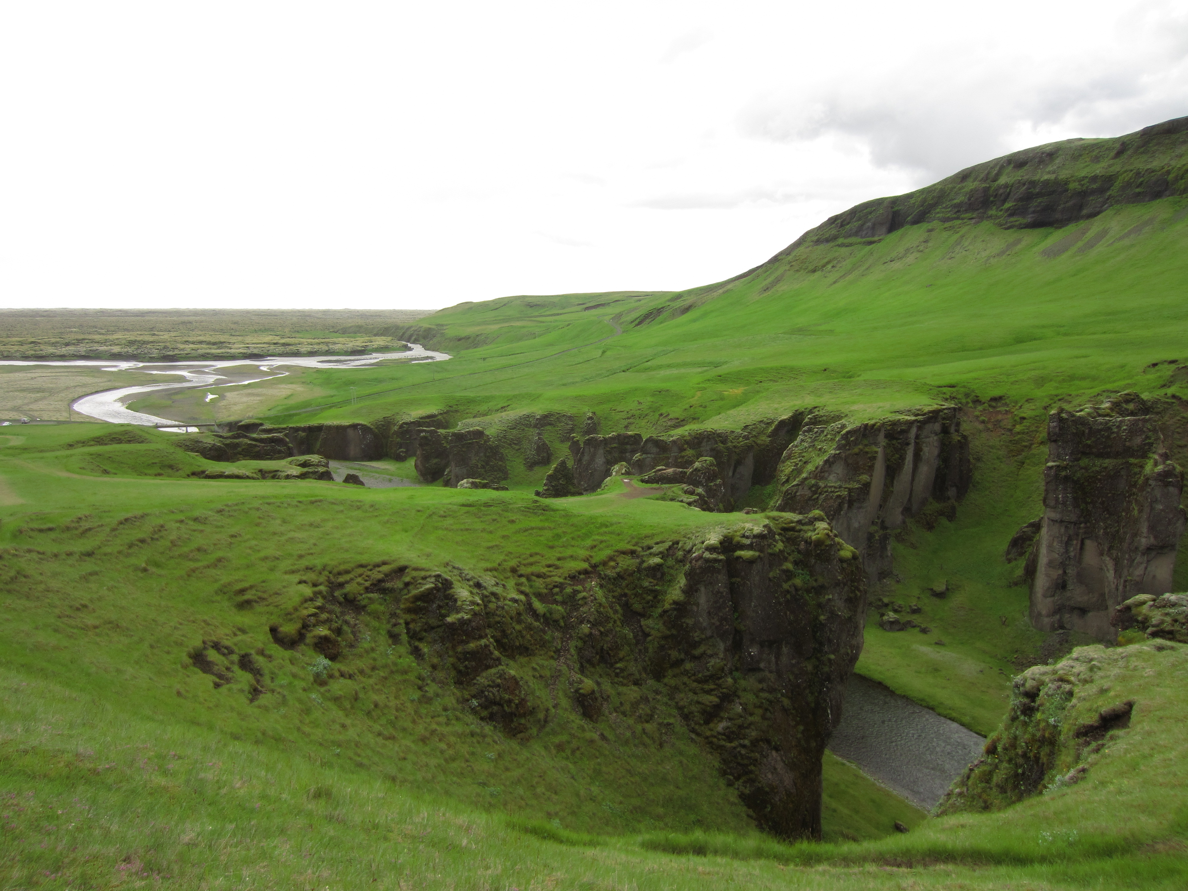
Easily climbed, the grassy hills around Fjaðrárgljúfur rose sharply, offering a hundred terrifying viewpoints. The palagonite walls of the canyon are not straight; they are smoothed off and eroded down, warped and precarious, like a mouth full of crooked teeth, shaping themselves into the tiniest (most vertigo-inducing) viewpoints.
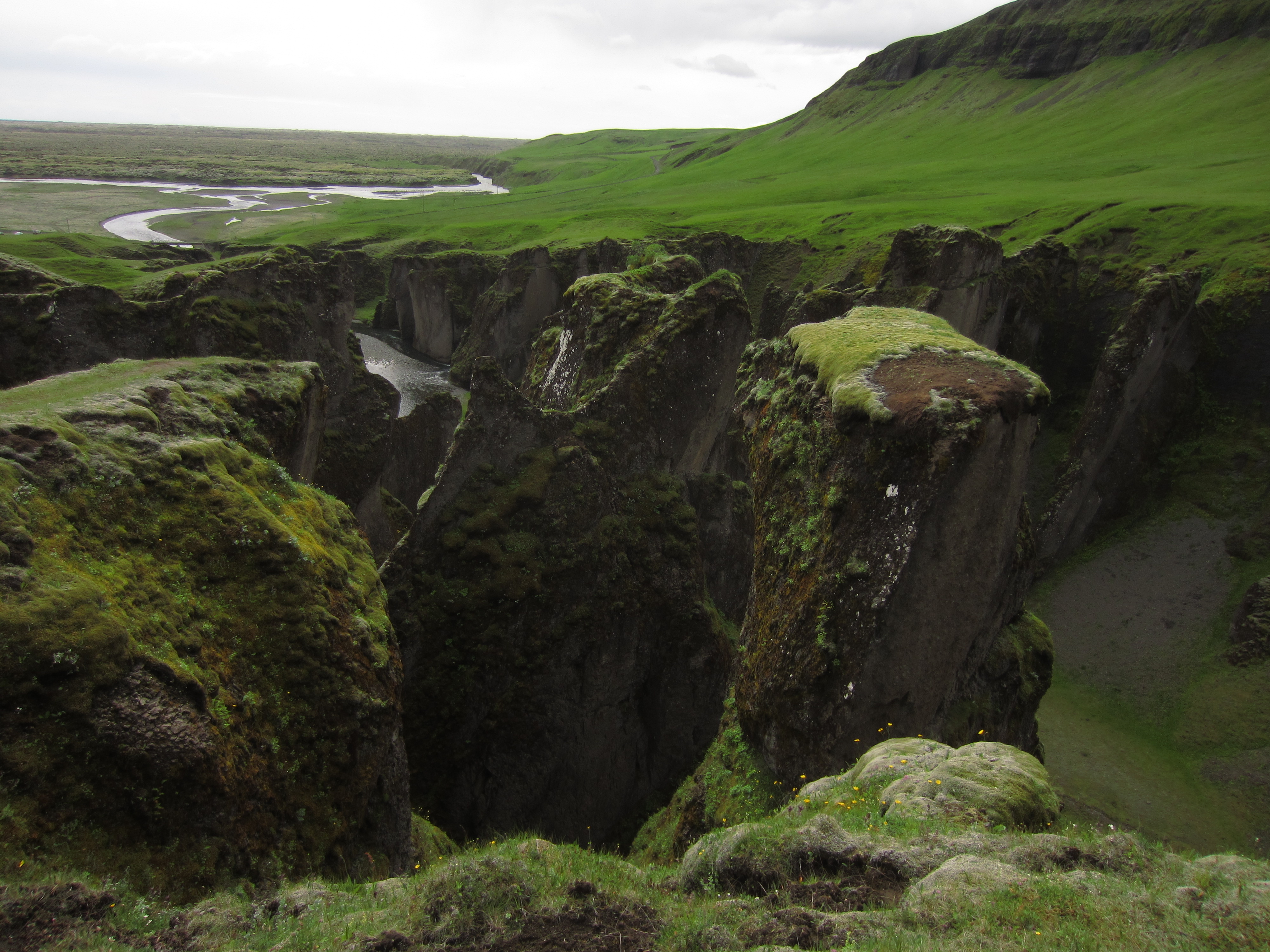
With the rolling hills behind, and the crumpled, moss-covered layered effect of the canyon, the spatial awareness made my head spin.

The paths allowing access to Fjaðrárgljúfur were nothing more than muddy shoe-made tracks through the grass. Occasionally a piece of string had been erected to protect us from the drop, or a helpful sign showing a stick figure plunging to his death.
The Icelanders had done well to balance the preservation of the site with all the necessary warnings. And so it should stay. There were a few more people in the distance, but we felt like we had the place to ourselves. The turnoff is ‘blink-and-you’ll-miss-it’, and the big tour buses can’t handle the road, and that’s a good thing.
I still couldn’t bring myself to stand on the edge…

Great article, that probably was my first slap in the face!!! The beach was really incredible!
Yeah, I wish we could have seen the other beach nearby too!!
Wow, that is some stunning scenery! That campsite looks incredible but you must have been freezing! How cold does it get there at night?
I’m not sure exactly…not freezing…but I usually slept in a sleeping bag, with pants, jumper, jacket and beanie!
Wow that canyon is amazing! Great post 🙂
Yeah, it was pretty amazing. Definately looks even more impressive in real life. I totally recommend visiting Iceland at some point!